Select Page
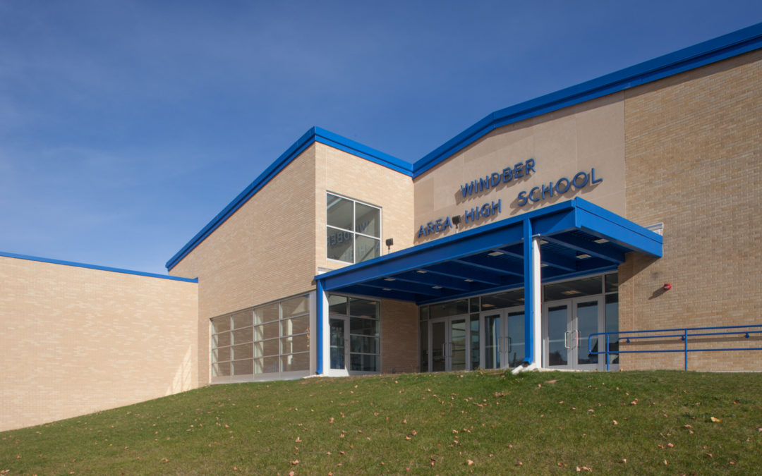
Windber Area Middle and High School

Windber Area Middle and High School

Windber Area Middle and High School
Windber Area School District

2301 Graham Avenue
Windber, Pennsylvania 15963

completed:2016

School

Capacity:899

Building Area

New Construction:31,821 SF
Renovated:98,500 SF
Total:120,650 SF

Although the Windber Area School District experienced a significant decline in student enrollment (of nearly 70%), at the same time, the aging school facility could no longer meet the educational goals of the District. McKissick Architects developed a strategy to alleviate the District's excess-outdated space by demolition, renovation, and addition. The design was a challenge amid the structure’s tight in-town location/site footprint. Nearly 50% of the original structure was demolished, allowing for site improvement. The site design reconfiguration improves the school’s access and safety, with a new bus loop separate from the automobile circulation lanes, and the addition of 112 parking spaces. The construction of the single two-story addition features pertinent areas, anchored by the Knowledge Commons. This anchor space, which adjoins the Guidance Office, the Library, Administration, Faculty Planning, Dining, and Small Group Study spaces, represents a collaborative area at the heart of the school. Other renovations include the conversion of a former locker room into an 8,300 square foot multi-lab STEM Center, and relocating the District Administration offices to one wing of the building.

Williamsport Area Middle School

Williamsport Area Middle School

Williampsort Area Middle School
Williamsport Area School District

Williamsport, Pennsylvania

School

Enrollment:1398

Building Area

New Construction:94,000 SF
Renovated:94,000 SF
Total:188,000 SF

Initially slated for demolition, this reconstructed and expanded facility has earned a LEED™ Silver rating. Originally constructed in 1951, the school was unique for its poured in place concrete construction of walls, floors, and roofing. Designed to support the 1940s view of junior high school instruction, the inflexible environment was an obstruction to modern middle school programming. A new rear classroom portion of the building was constructed to provide advanced science classrooms, teaching and athletic support space. The configuration now allows teaching team separation of grade level instruction. Contributions to the sustainable character of the facility include upgrades to the exterior building envelope, replacing the existing window units with triple glazed window/curtain wall assemblies, LED lighting, and the installation of energy-recovery ventilation coupled to a ground source geothermal heat pump HVAC system, with a total of 175 400’ deep-closed loop wells.

Caldwell County Granite Falls Middle School

Caldwell County Granite Falls Middle School

Caldwell County Granite Falls Middle School
Caldwell County Schools

90 North Main Street
Granite Falls, North Carolina 28630

Evaluation

Site Coverage:100481 SF

School

Institution:
Capacity:825

Building Area

New Construction:53,882 SF
Renovated:46,599 SF
Total:100,481 SF

The historic, yet aged, Granite Falls Middle School, fully integrated into the local neighborhood and beloved by its community, could no longer keep pace with the needs of a 21st century education. A strategy and design were developed by McKissick Architects to replace parts of the school, renovate, update, and adapt other areas while maintaining particular historic areas, such as the free-standing auditorium and gymnasium buildings, which will be restored yet equipped with modern upgrades. The phased plan enables continued use of the site, as well as reduces the cost of construction, bringing the project scope within the county's budget. The skeleton of the original 1930s school will remain; however, the interior will be entirely reconfigured as the “Technotorium,” a project-based learning center with studies to include robotics, programming, electronics, hydroponics, among other standard STEM offerings. A focal point of the design is the 230-year-old historic white oak where generations of students have rested under its branches. Not only will the tree be maintained, additional precautions are being undertaken to ensure that the tree will both survive and thrive throughout the construction, far into the future.

Westmont Hilltop Elementary School

Westmont Hilltop Elementary School

Westmont Hilltop Elementary School
Westmont Hilltop School District

827 Diamond Boulevard
Johnstown, Pennsylvania 15905

completed:2017

School

Grades:K-6
Institution:
Capacity:900

Building Area

New Construction:61,450 SF
Renovated:33,320 SF
Total:94,770 SF

The new Westmont Hilltop Elementary School was the outcome of a prior district-wide optimization plan that called for the realignment of the district’s grade-level structure. The resulting new school is located on the site of the former Westmont Hilltop Middle School which was demolished as part of the project. The available area for the new building was extremely limited as the site also houses the high school sports field/track complex. Substantial site reconfiguration was needed to better accommodate separation between cars, buses, and pedestrians.
Located in the historic district of Luzerne Street (a nationally registered streetscape) a careful selection of materials including stone, cement board clapboard, brick, and metal panels harmonizes the neighborhood's vernacular. The resulting solution entails construction of a high performance 3-story ICF (Insulated Concrete Form) classroom building. The building is functionally configured by floor into three schools: kindergarten, grades 1 to 3, and then grades 4 to 6. Upper level classrooms “paired” by subject matter, science and math, and then, English and social studies. To contain costs, the gymnasium wing of the former middle school was retained and incorporated into the new bThe new Westmont Hilltop Elementary School was the outcome of a prior district-wide optimization plan that called for the realignment of the district’s grade-level structure. The resulting new school is located on the site of the former Westmont Hilltop Middle School which was demolished as part of the project. The available area for the new building was extremely limited as the site also houses the high school sports field/track complex. Substantial site reconfiguration was needed to better accommodate separation between cars, buses, and pedestrians.

Located in the historic district of Luzerne Street (a national registry of historic streetscapes), a careful selection of materials including stone, cement board clapboard, brick, and metal panels harmonizes the neighborhood's vernacular. The resulting solution entails construction of a high performance 3-story ICF (Insulated Concrete Form) classroom building. The building is functionally configured by floor into three schools: kindergarten, grades 1 to 3, and then grades 4 to 6. Upper level classrooms were “paired” by subject matter, science and math, and then, English and social studies. To contain costs, the gymnasium wing of the former middle school was retained and incorporated into the new building. The gymnasium itself now houses a smaller gym, performance stage, cafeteria, kitchen, and updated locker rooms. Former shop areas (from the 1977 metal building structure) made way for a new STEM Learning Center, including a vocal and instrumental music suite, computer labs, art, and library space.

Reading “Castle” Intermediate High School

Reading “Castle” Intermediate High School

Reading Intermediate High School
Reading School District

215 North 12th Street
Reading, Pennsylvania 19604

School

Grades:9-10
Institution:
Capacity:3100

Building Area

New Construction:122,187 SF
Renovated:189,176 SF
Total:311,363 SF

McKissick Associates was asked to review the reuse of this functioning hospital following the Catholic Church’s decision to construct a replacement building. McKissick developed a plan that entailed a phased public-private partnership for the conversion of the building into a magnet school. The urban 8.3-acre St. Joseph’s site was completely transformed through the demolition of 250,000 SF. Original walls (including a four-story high stone chapel, a bell tower and 30” thick stone walls) were incorporated as exterior elements in the new additions. Existing hospital areas were converted to classroom use, while more than 122,187 SF of new construction accommodates large group instruction areas, a cafeteria, food service area, a kitchen, locker rooms, a gymnasium, band/choral rooms, a black box theatre, and an internet café. Waste material from demolition was used to create a hillside playing field.

The building was designed to create a small supportive learning environment. Construction of an additional story, above an existing building, houses four standalone (grades 9-10) school programs arranged around the District’s newly developed magnet programs: Arts and Humanities, International Business, Technology, and Agriculture Ecology and Science. Each of the four 600 student schools-within-a-school were arranged to be self-contained. Taking advantage of the natural slope (over 160-foot drop over a three-block distance), no student must move more than two stories to reach their respective core educational facilities.

Summerfield Elementary School

Summerfield Elementary School

Summerfield Elementary School
Guilford County Schools

7501 Summerfield Road
Summerfield, North Carolina

School

Grades:K-5
Institution:
Capacity:700
Core Capacity:850

Building Area

New Construction:52,400 SF
Renovated:42,000 SF
Total:94,400 SF

Summerfield Elementary School had consisted of 21 different buildings constructed between 1940 and 1985 including 14 modular classrooms. Not only does this 8.8-acre site lie within the town of Summerfield’s historic overlay district, but one of the site buildings (which also serves as the community gymnasium) was a treasured historic structure. The site was challenging, bisected by a high tension 14.4 KVA power company line, and seven septic drain fields which could not be disturbed, two community baseball fields, an inactive AMTRAK right-of-way, a Daughters of the American Revolution (DAR) memorial, and was the site of a Revolutionary War battle. It turned out that the site’s most buildable area also hosted an elevated water tower. Unlike prior building projects, this project was envisioned as a total reconstruction of the site. The solution to maximizing the buildable area was a two-story classroom wing with the creation of an internal kindergarten play courtyard. Extensive green features have been utilized in the design, driven by necessity as much as responsibility. The building itself is primarily ICF (insulated concrete form) construction in order to create a high-performing envelope. This method of construction also allows for a faster-paced construction schedule.

The Centrum

This wide lobby is the intersection of the two large public spaces: the cafeteria and library, and accommodates the high traffic of lunch changes and assemblies. The window seating bench allows this space to be used as a teaching area. The floor map fills a 27′ diameter circle where the main corridor’s gathering area looks into the kindergarten courtyard at the entrance to the cafeteria and the library. The blue circle above represents the dome of the sky.

The World from Summerfield...

This junction is also home to the school’s map of the world as centered on Summerfield, North Carolina which is identified by the red star. The map is a custom waterjet pattern using vinyl enhanced floor tile. This map may look a bit unusual because it was created from an equidistant azimuthal projection. That means that distances can be measured on a uniform scale from the center of the map to any other point along the radius.

It's a small world afterall...

This type of map is similar to great circle maps which are typically drawn looking down on the poles or from a point on the equator. This map differs in that the exact center of the map is the Summerfield Elementary School. Cities can be located on the map by calculating their distance from Summerfield, NC and locating them along the appropriate bearing. The map is oriented by the compass so that “north” on the map points north.

The floor map can be used as a tool for mathematics, geography, geometry and social studies.

Azimuthal equidistant what?

The floor map is designed so that places within 5,000 miles of Summerfield can be located on the map using a common scale when measured from Summerfield (at the center). This is called an “azimuthal equidistant projection”.

On this map, 21’ is equal to about 10,000 miles, so the scale factor is 1 foot = 477.213 miles. You can determine how far away a place is and its bearing (by using geometry or one of the many online resources) and then locate it on the map.

The Map Chain

Our interior designer (who has a great fondness for maps) created this map chain in order to illustrate how the map works. By placing the red star at the one end of the chain over the red star at the map center and extending the chain to the outside of the circle (as an airplane might fly), a number of cities can be seen according to their proximity to Summerfield. Each city tag has a bearing listed, so if the chain is aligned along the bearing angle, the city can be located on the floor map.

The chain itself has a marking at each foot (1 through 11) to assist in adding other cities to the chain in the future. Several other charms mark the chain as well. The globe marks the geographic north pole. The magnetic north pole is marked by a locket so that as the pole migrates, the information inside can be updated. The chain also has a working watch charm which is located at Greenwich, England, UK. It has been set for Greenwich Mean Time (or Zulu time).
Which way from here?

Distances were calculated using the website:http://distancecalculator.globefeed.com/World_Distance_Calculator.asp

Building Intervention ScopeDemolition